London Borough of Hackney
| London Borough of Hackney | |||
|---|---|---|---|
| — London borough — | |||
|
|||
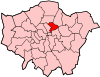
| Hackney shown within Greater London | |||
| Sovereign state | United Kingdom | ||
| Constituent country | England | ||
| Region | London | ||
| Ceremonial county | Greater London | ||
| Status | London borough | ||
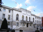
| Admin HQ | Mare Street, Hackney | ||
| Incorporated | 1 April 1965 | ||
| Government | |||
| - Type | London borough council | ||
| - Body | Hackney London Borough Council | ||
| - Leadership | Mayor & Cabinet (Labour) | ||
| - Mayor | Jules Pipe CBE | ||
| - MPs | Diane Abbott Meg Hillier |
||
| - London Assembly | Jennette Arnold AM for North East | ||
| - EU Parliament | London | ||
| Area | |||
| - Total | 7.4 sq mi (19.06 km2) | ||
| Area rank | 321st (of 326) | ||
| Population (2008 est.) | |||
| - Total | 212,200 | ||
| - Rank | 72nd (of 326) | ||
| - Density | 28,835/sq mi (11,133.3/km2) | ||
| - Ethnicity[1] | 47.1% White British 2.6% White Irish 11.2% Other White 1.6% White & Black Caribbean 0.8% White & Black African 0.8% White & Asian 1.2% Other Mixed 4.1% Indian 1.4% Pakistani 2.8% Bangladeshi 1.0% Other Asian 9.2% Black Caribbean 10.8% Black African 2.2% Other Black 1.4% Chinese 1.9% Other |
||
| Time zone | GMT (UTC0) | ||
| - Summer (DST) | BST (UTC+1) | ||
| Postcodes | {{{postcode_areas}}} | ||
| Police force | Metropolitan Police | ||
| Website | [LB Hackney LB Hackney] | ||
The London Borough of Hackney (pronunciation) is a London borough of North London,[2] and forms part of inner London.[3]
The south western tip of the borough is adjacent to the City and close to the Broadgate development. In this area some office development has taken place within the borough boundary. Also in the south west is Hoxton and Shoreditch which are central to the London arts scene and home to numerous clubs, bars, shops and restaurants, much of which is centred on Hoxton Square. The development of Shoreditch and Hoxton caused land value to increase in the area such that developers looked to other parts of the borough for development. Much of Hackney is inner-city in character and in places like Dalston large housing estates now sit side-by-side with gated communities.
The historical and administrative heart of Hackney is the area roughly extending north from Mare Street and surrounding the Church of St John-at-Hackney; known as Hackney Central. Hackney Town Hall Square has been developed as a new 'creative quarter'. Surrounding the public square itself is the now bankrupt Ocean music venue, a new Library, Technology and Learning Centre, Hackney Museum and the refurbished Hackney Empire. A new town hall complex is being built behind the existing building. South Hackney abuts Victoria Park (which is in neighbouring Tower Hamlets) and terraced Victorian and Edwardian housing stock has survived in the area.
To the north of the borough are Upper and Lower Clapton, Stamford Hill and Stoke Newington. To the east is the large open space of the Hackney Marshes and the districts of Hackney Wick and Homerton. Light Industries employing over 3000 people have been claimed from this area to allow the land around the River Lea (the eastern boundary) to be used for the 2012 Summer Olympics, making the area one of the Host Boroughs for the games.
There are 1,300 listed buildings in Hackney, including the iconic grade II* Hackney Empire, Tudor Sutton House, and the grade I medieval St Augustine's tower. The Borough contains 25 conservation areas including Clapton Square, and many urban open-spaces including Clapton Common and Clissold Park. Conservation areas also protect large areas of Georgian and Victorian housing, and areas of industrial heritage.[4]
Contents |
History
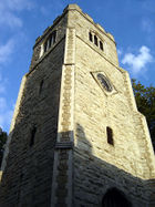
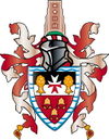
The borough was formed in 1965 from the area of the former metropolitan boroughs of Hackney, Shoreditch and Stoke Newington. The new council adopted elements of its constituents in the new coat of arms; Shoreditch by three bells from Shoreditch Church (recalled in the rhyme Oranges and Lemons), Stoke Newington by two trees bearing fruit, and Hackney by the eight pointed cross of the principal landowners of the parish in the middle-ages, the Order of St John of Jerusalem. The shield is surmounted by a representation of St Augustin's Tower, the remains of Hackney's former parish church in the historical centre of Hackney. The motto is Justitia turris nostra, translated as Being fair is what makes us strong.[5] The Queen's portrait hangs in the council chamber, wearing the robes of the Venerable Order of Saint John.
Individual parts of the borough have a rich history. The Roman road, Ermine Street forms the western edge of the borough. Much of the rest of the land was covered with open oak and hazel woodlands, with marshland around the rivers and streams that crossed the area. Hackney lay in the Catuvellauni tribal territory.[6] The eastern boundary of the borough is formed by the River Lee. This was an ancient boundary between pre-Roman tribes, and in the Roman era, was tidal as far as Hackney Wick and continued as the boundary between the historic counties of Middlesex and Essex.
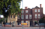
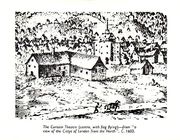
In the Tudor period the lands of the religious order were seized and Hackney became a retreat for nobility around Hackney Central and Homerton, including Henry VIII's palace by the Lee Bridge roundabout, where BSix Sixth Form College stands today.[7] Sutton House, on Homerton High Street, is the oldest surviving dwelling in Hackney, originally built as Bryck Place for Tudor diplomat Sir Ralph Sadleir in 1535. The village of Hackney flourished from the Tudor to late Georgian periods as a rural retreat – brought to an end by the construction of the railway in the 1850s. Notable residents have included Thomas Sutton, Samuel Courtauld, Joseph Priestly, a governor of the Bank of England and the founding director of the Honourable East India Company.
London's first Tudor theatres were built in Shoreditch and the Gunpowder Plot was first exposed at nearby Hoxton.[8] Many grand houses stood in Stoke Newington and Stamford Hill, with the latter providing a haven for Hackney's many orthodox Jewish residents from the 1930s. Alfred Hitchcock made many of his first films in Hoxton at the Gainsborough Studios in Poole street.[9]
After industrialisation, extensive post-war development and immigration the area is now gentrifying its large stock of Georgian and Victorian terraces and new apartments, warehouse conversions and period restorations are being built.[10] Despite development it is inner London's 'greenest borough' and London Transport's 'best bike borough 2006',[11] with 62 parks and open spaces, covering 815 acres (3.3 km2).[12] Seven Hackney parks have now achieved Green Flag status.[13] One, Abney Park, became scheduled in 2009 as one of Britain's historic park and garden at risk from neglect and decay.[14] Hackney Marshes play host to the largest collection of football pitches in Europe; and will be the site of part of the 2012 Summer Olympics.
Governance
The borough consists of two parliamentary constituencies: Hackney North and Stoke Newington (represented by Diane Abbott MP) and Hackney South and Shoreditch (represented by Meg Hillier MP; both are Labour Party Members of Parliament. The borough is in the North East London Assembly constituency returning Jennette Arnold AM, as the directly elected Assembly Member. Hackney is part of the London constituency in the European Parliament.
Unlike most other English local authorities, the Borough is now governed by a directly-elected Mayor who is also the political leader of the council. The Mayor – currently Jules Pipe CBE[15] – is supported by a cabinet, councillors and a Speaker, currently Councillor Sally Mulready; who fulfils the civic and ceremonial duties previously undertaken by the (non-political) mayor.[16]
At the Hackney Council election on 6 May 2010 the Labour Party were returned with 50 councillors; winning six additional seats. The Conservative Party forms the largest opposition party on the council with four councillors; and the Liberal Democrats have three.[17]
Between 1999 and 2001 serious concerns were expressed about Hackney's performance as a council by the Audit Commission, and many aspects of council services were failing.[18] This led to considerable negative press coverage that still colours perceptions of the area, but is at odds with the changing realities of the borough. In 2005, MORI identified that residents were significantly more satisfied than they had been in 2002, and in 2007 the Audit Commission showed that improvements continue to be made in council performance, with the council now achieving 'three stars', and described as 'improving strongly'.[19] Every ward remains among the 10% most deprived in the country, with 47% of children living in low income households.[18]
Hackney has a reputation as one of the most crime-affected London boroughs, but cooperation between local police and council has resulted in the borough experiencing a bigger drop in crime than in any other London borough in the four year period up to 2007 (28% reduction).[20]
Geography
Location
The London Borough of Hackney is an inner London Borough within Greater London. It is to the north-east of the City of London; and neighboured by the London Boroughs of Tower Hamlets, to the south; Islington to the west at Southgate Road; Haringey to the north. On the east, the River Lee forms the boundary with Waltham Forest; and to the south-east is Newham. Historically, this river has formed a boundary between the former counties of Middlesex and Essex.
Hackney Town Hall is about 5 miles (8 km) north-east of Charing Cross; and 3.8 miles (6.1 km) from the GLA City Hall near Tower Bridge.
Districts and postcodes
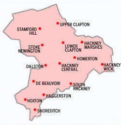
The most southerly district in the borough is Shoreditch, adjacent to the City. To the north-west, bordering Islington, the City, and north of Old Street is Hoxton. To the north of Shoreditch is Haggerston, north of Hackney Road — which forms the boundary with Bethnal Green in Tower Hamlets.
Settlements to the west of the borough followed the line of the former Ermine Street, with De Beauvoir Town — a Victorian estate to the west of the (now) Kingsland Road. Further north, lie Dalston, Stoke Newington and Stamford Hill — where the borough meets Haringey.
A further group of settlements follow another north-south radial road, with South Hackney to the east of Cambridge Heath Road — north of Victoria Park; and Hackney Central commencing where this street becomes Mare Street. London Fields was common land to the west of this point, but now forms a district in its own right. To the north, Homerton lies immediately east of the centre of Hackney. The borough boundary, further east is formed by the River Lee; and Hackney Wick, the Hackney Marshes, Lower and Upper Clapton all lie on the eastern boundary of the borough.
Postal districts were assigned to the former parts of the borough in 1857/8. Most of the borough would originally have been covered by a planned 'NE' postal district, but this was abolished in 1866. Most of the borough is covered by the eastern postal district, but Shoreditch benefits from five separate postcodes; and areas to the west of Kingsland Road and in the north of the borough are predominantly covered by the northern postal district.
Traditionally, much of the borough was considered a part of east London; with Hoxton and Shoreditch being part of the East End of London. In the 2008 revision of the London Plan, the borough was reassigned to the north London sub-region.[2]
Topography
The London Borough of Hackney covers an area of 19.06 square kilometres (7.4 sq mi). Its primary geographic feature is the course of the River Lee; and the associated River Lee Navigation, which passes through Hackney Cut — an artificial channel of the Lee built in 1770 across the Hackney Marshes to straighten a meander of the natural river. A tributary of the Lee, Hackney Brook was fully culverted in 1860 by the Metropolitan Board of Works.[21]
The New River passes through the Borough from near Finsbury Park, and flows towards Islington. The Regents Canal also crosses the Borough below De Beauvoir Town in the west, joining the Hertford Union Canal below Victoria Park.[21]
Within the Borough, the land rises westward from the Lee reaching 30 metres (98 ft) above sea level at Clapton Common and Stamford Hill. The area around Victoria Park, in the south of the borough lies about 15 metres (49 ft) above sea level. At Spring Hill, in Upper Clapton the road descends sharply from 25 metres (82 ft) to only 10 metres (33 ft) at High Hill Ferry, on the Lee Navigation.[21]
Geology
The Lea and Hackney Marsh are underlain by alluvium soils; and the higher ground between Homerton and Stamford Hill is formed on a widening bed of London Clay. Brickearth deposits are within tongues of clay extending beneath Clapton Common, Stamford Hill and Stoke Newington High Street. The centre and south western districts lie on river terrace deposits of Taplow Gravel. Victoria Park and Well Street Common are on flood plain gravel.[21]
Climate
This data was taken between 1971 and 2000 at the nearest national weather station in Greenwich; around 7 miles (11.3 km) south of Hackney Town hall:
| Climate data for London (Greenwich) | |||||||||||||
|---|---|---|---|---|---|---|---|---|---|---|---|---|---|
| Month | Jan | Feb | Mar | Apr | May | Jun | Jul | Aug | Sep | Oct | Nov | Dec | Year |
| Average high °C (°F) | 7.9 (46.2) |
8.2 (46.8) |
10.9 (51.6) |
13.3 (55.9) |
17.2 (63) |
20.2 (68.4) |
22.8 (73) |
22.6 (72.7) |
19.3 (66.7) |
15.2 (59.4) |
10.9 (51.6) |
8.8 (47.8) |
14.8 (58.6) |
| Average low °C (°F) | 2.4 (36.3) |
2.2 (36) |
3.8 (38.8) |
5.2 (41.4) |
8.0 (46.4) |
11.1 (52) |
13.6 (56.5) |
13.3 (55.9) |
10.9 (51.6) |
8.0 (46.4) |
4.8 (40.6) |
3.3 (37.9) |
7.2 (45) |
| Precipitation mm (inches) | 51.9 (2.043) |
34.0 (1.339) |
42.0 (1.654) |
45.2 (1.78) |
47.2 (1.858) |
53.0 (2.087) |
38.3 (1.508) |
47.3 (1.862) |
56.9 (2.24) |
61.5 (2.421) |
52.3 (2.059) |
54.0 (2.126) |
583.6 (22.976) |
| Avg. rainy days (≥ 1 mm) | 10.9 | 8.1 | 9.8 | 9.3 | 8.5 | 8.4 | 7.0 | 7.2 | 8.7 | 9.3 | 9.3 | 10.1 | 106.6 |
| Sunshine hours | 45.9 | 66.1 | 103.2 | 147.0 | 185.4 | 180.6 | 190.3 | 194.4 | 139.2 | 109.7 | 60.6 | 37.8 | 1,461.0 |
| Source: Met Office [22] | |||||||||||||
Demography
| Population | ||
|---|---|---|
| Year | Pop. | %± |
| 1801 | 14,609 | — |
| 1811 | 19,523 | 33.6% |
| 1821 | 25,342 | 29.8% |
| 1831 | 35,482 | 40.0% |
| 1841 | 68,246 | 92.3% |
| 1851 | 94,961 | 39.1% |
| 1861 | 172,385 | 81.5% |
| 1871 | 249,810 | 44.9% |
| 1881 | 327,234 | 31.0% |
| 1891 | 369,209 | 12.8% |
| 1901 | 374,132 | 1.3% |
| 1911 | 379,120 | 1.3% |
| 1921 | 368,469 | −2.8% |
| 1931 | 358,117 | −2.8% |
| 1941 | 305,501 | −14.7% |
| 1951 | 260,626 | −14.7% |
| 1961 | 240,521 | −7.7% |
| 1971 | 221,975 | −7.7% |
| 1981 | 179,536 | −19.1% |
| 1991 | 187,792 | 4.6% |
| 2001 | 202,819 | 8.0% |
| Source: A Vision of Britain through time | ||
In 1801, the civil parishes that form the modern borough had a total population of 14,609. This rose steadily throughout the 19th century, as the district became built up; reaching 95,000 in the middle of the century. When the railways arrived the rate of population growth increased — reaching nearly 374,000 by the turn of the century. This increase in population peaked before World War I, falling slowly in the aftermath until World War II began an exodus from London towards the new towns under the Abercrombie Plan for London (1944).[23] The population is now rising again, and the 2001 census gives Hackney a population of 202,824.[24]
The population is ethnically diverse. Of the resident population, 89,490 (44%) people describe themselves as White British. 30,978 (15%) are in other White ethnic groups, 53,009 (25%) are Black or Black British, 20,000 (9.4%) are Asian or Asian British, 8,501 (4%) describe themselves as 'Mixed', and 6,432 (3%) as Chinese or Other.

There is also a large Turkish population in Hackney. Turkish-speaking communities are located in all parts of the Borough, though there is a greater concentration in the north and in central Hackney. Stoke Newington, Newington Green and Dalston have the greatest concentration of population and in particular Green Lanes, running from Manor House down to Newington Green Roundabout, has a high concentration of businesses and shops.
132,931 (66%) of the resident population were born in the UK. A further 10,095 (5%) were born in other parts of Europe, and the remaining 59,798 (29%) born elsewhere in the world.
The 2001 census also shows Christianity is the biggest religion in Hackney, with (44%) Christian; (18%) Muslim; (4%) Jewish; and (3%) belong to other religions. A further (19%) stated no religion, and (12%) did not state a religion.
32% of householders are owner–occupiers.
Education
In 2002, the borough entered into a ten year contract with the Learning Trust, an independent collaborative body that organises education for Hackney's 27,000 pupils in over 70 schools, nurseries and play centres. The trust was set up in response to an OFSTED report that identified failings in the then existing system.[25] Two of London's most successful City Academies are in Hackney with another two in development and plans to rebuild or renovate every other Hackney school by 2016.
Transport
Hackney is currently poorly served by London Underground services. Only one station, Manor House is located in the Borough, on its extreme north-westen fringe on the boundary with Haringey. Old Street sits only a few yards south-west of the Borough in Islington.
Two London Overground lines serve the borough. North London Line crosses from west to east while East London Line starts from Dalston Junction and go south. The Lea Valley Lines also pass through Hackney.
Crossrail 2 would provide a direct Underground line to serve Hackney, Dalston and Homerton although it is currently undecided whether this would be operated by London Underground or as a main line.
London Overground
North London Line Travelling west to east — nearest London Overground stations are Dalston Kingsland, Hackney Central, Homerton and Hackney Wick
East London Line Travelling north to south — nearest London Overground stations are Dalston Junction, Haggerston, Hoxton and Shoreditch High Street
Lea Valley Lines
These stations are served by National Express East Anglia:
- Stamford Hill railway station
- Stoke Newington railway station
- Rectory Road railway station
- Clapton railway station
- Hackney Downs railway station
- London Fields railway station
Notable associated people
Notable attractions and institutions
- Arcola Theatre - studio theatre
- The Circus Space - circus school
- Geffrye Museum - decorative arts museum
- Hackney Empire - theatre
- Hoxton Hall - community centre and performance space
- Newington Green Unitarian Church - London's oldest nonconformist place of worship
- Sutton House - Heritage house and museum
- Transition Gallery - contemporary art project space
- Victoria Miro Gallery - contemporary art gallery
- White Cube - contemporary commercial art gallery
- Vortex Jazz Club - live jazz venue
Twinned towns
The London Borough of Hackney has formal twinning arrangements with:–
| Flag | Country | Town[26] | Region |
|---|---|---|---|
| Barbados | Bridgetown | Caribbean | |
| France | Suresnes | Western Paris | |
| Germany | Göttingen | Lower Saxony | |
| Grenada | St George's | Caribbean | |
| Israel | Haifa | Northern Israel | |
| Russia | Presnensky District | Moscow suburb |
The borough also has informal links with South Africa, Turkey, and Saint Vincent and the Grenadines. The Homerton University Hospital has its own twinning arrangements with the Rambam Medical Centre (Haifa, Israel) and St George’s Hospital (Grenada). Schools are encouraged to pursue links with specific schools abroad – such as the arrangement between Our Lady's and a school in Hangzhou, South West China.[26]
 An informal twinning with the township of Alexandra, South Africa.[26]
References
- ↑ Data Management and Analysis Group, Greater London Authority, Demography Update October 2007, (2007)
- ↑ 2.0 2.1 Map 5A.1 - London's sub-regions The London Plan (Greater London Authority, 2008) accessed 13 November 2009
- ↑ Office of Public Sector Information - London Government Act 1963 (c.33) (as amended) accessed 13 November 2009
- ↑ Hackney Society photographic survey accessed 23 Jan 2007
- ↑ Details extracted from a council information sheet — May 2007
- ↑ Roman Landscape (Brickfields Building Exploratory) accessed 10 May 2007
- ↑ 'Hackney: Settlement and Building to c.1800', A History of the County of Middlesex: Volume 10: Hackney (1995), pp. 10-4 Date accessed: 02 Oct 2006
- ↑ Houses of Parliament factsheet on event accessed 6 Mar 2007
- ↑ Visiting Hackney accessed 10 May 2007
- ↑ Location, Location: Best and Worse Hackney One Year On (Channek 4 TV) accessed 7 Nov 2007
- ↑ Hackney wins best bike borough (LBH Press release, 6 April 2006) accessed 7 Nov 2007
- ↑ Parks department (LB Hackney) accessed 7 Nov 2007
- ↑ Hackney Today 188 21 July 2008
- ↑ English Heritage's 'At Risk' register accessed 5th July 2010
- ↑ Results for the Mayoral Election on 6 May 2010 accessed 26 May 2010
- ↑ The Speaker of Hackney Council accessed 27 May 2010
- ↑ Mayor and Council Elections 2010 accessed 26 May 2010
- ↑ 18.0 18.1 Corporate Assessment Report: London Borough of Hackney (The Audit Commission August 2006) accessed 4 Dec 2007
- ↑ City's councils get top ratings (BBC News) 7 February accessed 8 Feb 2008
- ↑ Hackney Today 157 23 April 2007 accessed 6 June 2007
- ↑ 21.0 21.1 21.2 21.3 Hackney: Introduction, A History of the County of Middlesex: Volume 10: Hackney (1995), pp. 1-4. Date accessed: 13 June 2009
- ↑ "Met Office: Climate averages 1971-2000". Met Office. http://www.metoffice.gov.uk/climate/uk/averages/19712000/sites/greenwich.html.
- ↑ A Vision of Britain through time accessed 20 February 2009
- ↑ Statistics for ethnicity [1], country of birth [2], and religion [3] are from the UK census.
- ↑ Learning Trust history accessed 5 May 2007
- ↑ 26.0 26.1 26.2 Twinning (LB Hackney) Accessed 2008-09-19
External links
London/Hackney travel guide from Wikitravel
- Official site of Hackney council
- Hackney Conservative Party Links to Conservative Councillors, London Assembly Members and MEPs
- Hackney Labour Party Links to Labour Councillors, London Assembly Members and MEPs
- Hackney Liberal Democrats Links to Liberal Democrat Councillors, London Assembly Members and MEP
- Hackney Green Party Links to Green Councillor, London Assembly Members and MEP
- Hackney Independent Link to Hackney Independent Party
- Hackney Rugby Football Club
- The Hackney Society (Heritage Conservation)
- Hackney Walks
- Tudor Life in Hackney (National Archives)
- Hackney Silver Surfers
- Timeline Educational site presenting Hackney history.
- The Hackney Podcast
|
|||||||||||||||||||||||
|
||||||||||||||